
Punta Campanella and Ieranto Bay: How to Visit Them
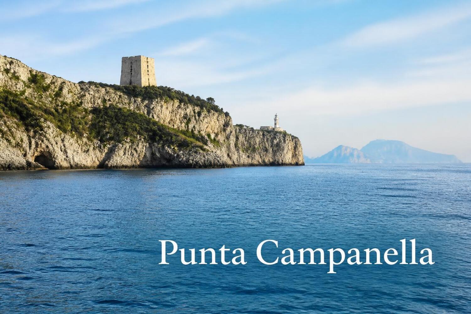
Image created with AI

Punta Campanella and the Bay of Ieranto are the wild heart of the Sorrento Peninsula, the point where the Gulf of Naples meets the Gulf of Salerno. The promontory narrows to just a few kilometers from Capri, nestled between Mediterranean scrub and waters protected by the Marine Protected Area.
It's one of the most beautiful hikes in Campania, perfect for those who love walking with the sea looming beneath their feet. This guide contains everything you need to plan your visit: the two main trails, the marine area's rules, the FAI site's opening hours, parking, and practical advice.
Ieranto and Punta Campanella can only be visited with respect for the nature of the place, which is also its greatest value.
Punta Campanella: the promontory between two gulfs
Punta Campanella is the southernmost tip of the Sorrento Peninsula. In ancient times, it was the Promontorium Minervae , dedicated to Athena, the goddess of wisdom. A temple founded by the Greeks and later used by the Romans once stood here, and archaeological traces of this temple remain around the tower.
Legend has it that Ulysses encountered the Sirens here, and for this reason the place is also linked to their cult. The promontory is dominated by the Punta Campanella Tower , also known as Torre Minerva.
The tower was built by Robert of Anjou between 1334 and 1335 as a lookout post against pirates, and was rebuilt in 1556 after its destruction by the Turks. A bell was rung to raise the alarm, and it is from this sound that the name Campanella (literally, "little bell") derives.
Next to the tower is the Punta Campanella lighthouse , still in operation. To the left of the tower, a steep path descends to the Grotta delle Sirene , with an Oscan inscription from the first half of the 2nd century BC carved into the rock.
From the lookout, the view sweeps across Capri , which seems within reach, Ischia , and the Faraglioni . To the west lies the Bay of Ieranto, to the east the Amalfi Coast: it's one of the most breathtaking panoramic views in Campania.
The path from Termini: how to get to the tower
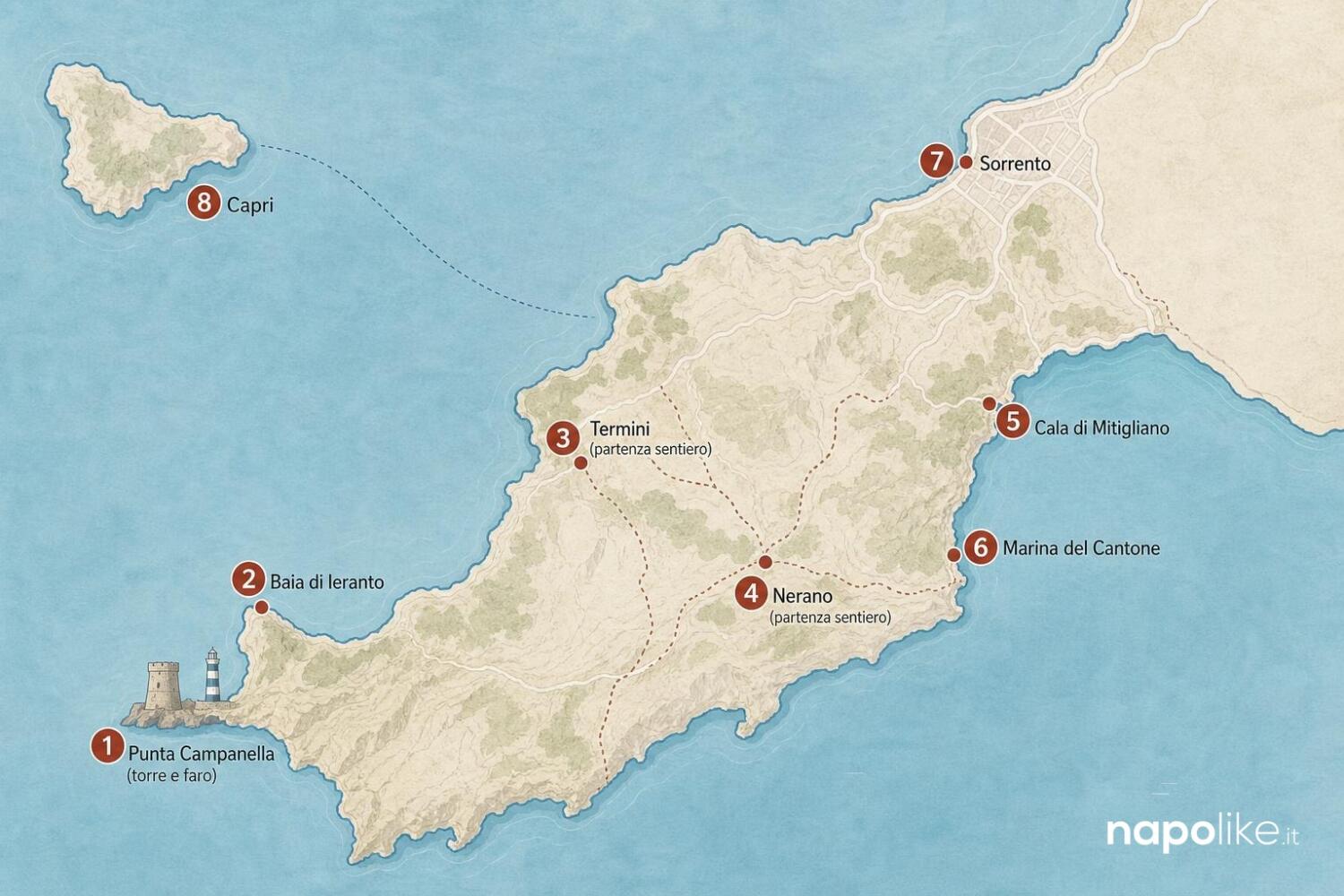
The easiest access on foot starts from Termini , a hamlet of Massa Lubrense. From Piazza Santa Croce, take Via Campanella and, after about 200 meters, turn right onto Via Minerva , a Greco-Roman mule track from the 4th century BC, still partially paved.
The route is approximately 4 kilometers long with an elevation gain of 300 meters: an average of one hour there and one hour back, for a total duration of about two hours. The gradient is constant but never extreme, suitable for those with a minimum level of fitness.
On the descent, you'll encounter the Torre di Fossa Papa , another watchtower from the peninsula's defensive system. The trail is part of the Athena Trail , the circular circuit that connects Punta Campanella to Monte San Costanzo.
Pros: continuous panorama of Capri and the two gulfs, well-marked historical route, can be combined with a visit to the Bay of Ieranto.
Cons: Uphill stretch on the way back, almost no shade, not recommended in the midday heat or with unsuitable footwear.
Visitors reviewing the trail on Google and TripAdvisor describe it as one of the most beautiful hikes on the coast. Two common pieces of advice are: start early in the morning and bring at least a liter of water per person.
In summer the trail is very sunny, so a hat and sunscreen are essential.
Ieranto Bay: a FAI property
Ieranto Bay is one of the most photographed spots on the Sorrento Peninsula: a crescent of rocks and pebbles nestled between promontories, with emerald water and a farmhouse surrounded by olive trees.
Since 1987 it has been entrusted to the FAI, the Italian Environment Fund , which takes care of its protection and guided tours.
The site preserves the memory of the quarry and cement factory that the Italcementi family operated there for decades, before nature reclaimed its power. Today, the bay is also famous for its Ieranto capers , which grow wild on the dry stone walls and are still harvested today.
Near the farmhouse, there's a picnic area, while the beach is free and unequipped, with very little shade. Pros: pristine landscape, clear water, qualified FAI guides, and a picnic area.
Cons: Access is on foot only, there are no umbrellas or beach services, and bathing in some areas is temporarily prohibited by order of the Castellammare di Stabia Port Authority in June 2026.
Before leaving, always check the special opening hours on the FAI website: in winter, guided tours are only available on weekends, while from March 1st to October 31st the property can be visited from Tuesday to Sunday.
Also check the updated bathing situation, which is subject to temporary ordinances from the Coast Guard.
The trail from Nerano: the official FAI departure point
The route indicated by the FAI to reach Ieranto Bay starts from Nerano , a hamlet of Massa Lubrense. From the village square, take Via Ieranto , a marked trail of medium difficulty with an elevation gain of about 250 meters.
In about 45 minutes you reach the bay, walking among olive trees and broom bushes with a view of the Amalfi coast.
Parking is limited in Nerano: there's a small lot at the entrance to the town, otherwise you can leave your car along the road. Alternatively, you can take the SITA bus from Sorrento, heading to Marina del Cantone, stopping in Nerano: the ride takes about an hour.
Pros: Official starting point of the FAI property, clear signage, pairs well with a seafood lunch in Marina del Cantone. Cons: Difficult parking in high season, narrow access road, and a final uphill stretch on the way back.
Those who want to extend the hike can continue from Ieranto towards Termini along CAI trail 339, which connects the two towns. Many hikers organize the Nerano-Ieranto-Termini loop, returning by bus or with two cars parked at each end.
Hikers on Google recommend this loop especially in spring and autumn, when the sun is less strong and the light on the bay is perfect for photos.
By boat: the rules of the Marine Protected Area
The waters around Punta Campanella are part of the Punta Campanella Marine Protected Area , managed by a consortium of six municipalities: Massa Lubrense, Piano di Sorrento, Positano, Sant'Agnello, Sorrento, and Vico Equense. For those arriving by sea, the rules are specific and must be respected.
The area is divided into three zones. In zone A , the nature reserve around the Scoglio del Vervece and Vetara, near Li Galli, access, navigation, and anchoring are prohibited. In zone B , sailing, rowing, and pedal boats are permitted, with severe restrictions for motors.
In Zone C, navigation is freer, but anchoring is only permitted in designated areas, such as Marina di Puolo, Mitigliano, and Marina del Cantone-Recommone, and only during the day, from 8:00 am to 8:00 pm.
Speed is limited to 5 knots within 300 meters of the coast and 10 knots beyond. Jet skis, personal watercraft, and water skiing are prohibited everywhere, as are foil boats, as per the 2026 regulation. Spearfishing is prohibited throughout the area.
In the stretch between Punta Campanella and Punta Penna, which includes the Ieranto Bay , motorized navigation is prohibited except to reach the authorized buoys.
The Ieranto buoys are reserved for local operators, passenger transport, and fishing tourism: they should not be considered a public mooring.
The other buoy moorings are in Mortelle and Isca-Crapolla . Pros: spectacular sea views, the chance to see caves and sea stacks, and snorkeling in permitted areas.
Cons: Complex rules to understand, paid mooring by reservation, and severe fines for those who do not comply.
Boaters' reviews cite the area as one of the most beautiful in Italy. However, they recommend consulting the MPA's official maps before entering: the boundaries of the zones are not immediately visible, and parts of the site may be outside the permitted range.
Cala di Mitigliano: a must-see detour
Along Via Minerva, before reaching the tower, a right turn leads to Cala di Mitigliano , a pebble cove overlooking Capri, reached by a short descent. It's one of the most beloved coves on the Sorrento Peninsula, with clear water and a rapidly sloping seabed.
Pros: Short stop, crystal-clear water, anchoring permitted in Area C for those arriving by sea. Cons: Pebbly beach, few amenities, very busy in summer.
Those visiting Punta Campanella on foot can include Mitigliano in their outward or return journey without significantly altering their travel time: it adds about 30-40 minutes in total. Swimmers rate it as one of the most beautiful coves in the gulf, but recommend rock shoes for the seabed.
How to get there and practical advice
Massa Lubrense can be reached by car from Sorrento or Sant'Agata sui Due Golfi. To reach Termini, from the center of Massa, follow Via IV Novembre towards Marciano; from Sant'Agata, continue along Via dei Campi. Park in Termini square or in the streets opposite, within the blue lines.
To reach Nerano, take the A3 motorway exit at Castellammare di Stabia and follow the road along the peninsula, passing through Meta and Sant'Agata sui Due Golfi.
By bus, the SITA line departs from Sorrento for Marina del Cantone, which passes through Termini and stops in Nerano. Check the schedule on the Sita Sud Trasporti website, as services are limited during the low season.
The best time to visit is spring and fall : in summer, the heat makes the climb back arduous, and on weekends, the bay is very crowded. Bring hiking boots, plenty of water, a hat, a swimsuit, and a packed lunch: there are no drinking fountains or refreshments along the trails.
The route is not suitable for people with mobility difficulties, and the sections exposed to the sun require planning an early morning departure.
FAQ
How long is the trail to Punta Campanella? From Termini, it's about 4 kilometers with a 300-meter elevation gain: one hour there and one hour back, for a total duration of about two hours.
Can I reach Ieranto Bay by boat? Access and mooring of private motorboats are prohibited. Access is possible only on foot or using authorized buoys, which can be booked in Ieranto and are reserved for local operators, passenger transport, and fishing tourism.
Is Ieranto Bay open year-round? Yes, but guided tours in January, February, November, and December are only held on Saturdays and Sundays. From March 1st to October 31st, the FAI property is open to visitors from Tuesday to Sunday.
How far is Punta Campanella from Capri? Just over 3 kilometers as the crow flies: from the tower's lookout, the island seems within reach, and on calm seas, you can see the Faraglioni in every detail.
Do you need a permit to walk the trails? No, the trails to Punta Campanella and Ieranto are public and do not require permits. FAI guided tours of the bay can be booked on the Italian Environment Fund website.
Before leaving, also consult the other guides in the series to organize your stay: the itineraries of the most beautiful villages of the Sorrento peninsula , the most beautiful beaches , the guide to getting to Sorrento and the best farmhouses.
For those who have more time, a day tour of the peninsula from Massa Lubrense to Sant'Agata sui Due Golfi is described in the dedicated guide , while trekking lovers will find inspiration in the Path of the Gods.
In the area, don't miss the IGP limoncello shops and the typical products of the peninsula , with an eye on the mozzarella dairies of Capaccio Paestum.
Find out more from Napolike.com
Subscribe to receive the latest articles sent to your email.